When you cross the Missouri River, the West comes alive. From Buffalo ranching at Triple U, the film site for Kevin Costner’s movie Dances With Wolves, to the largest sale barn in five states “ this is the frontier of Fort Pierre. Fort Pierre is the hometown of nine-time World Champion rodeo star Casey Tibbs and also is known for world-class pheasant hunting and walleye fishing. The country-side has not changed much from the days when Meriwether Lewis and William Clark explored the young nation’s newest land purchase for President Thomas Jefferson “ and it remains true to the friendliness found in the midwest.
History
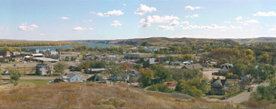
Looking out from the bluffs atop the Missouri River, what must French explorers thought about discovering the land of Fort Pierre? The rugged terrain, a mighty winding river, the raw beauty of endless land, and a prominent central location on a major river were attractive to early explorers, settlers and traders. Profitable fur trading was established in the late 1700’s, and by 1830 Fort Pierre was a bustling trade center and steamboat stop. In 1855, the first military fort in the northwest was established. By the time of the Black Hills Gold Rush, Fort Pierre was the major transportation and distribution hub in the territory.
Recreation / Community Events
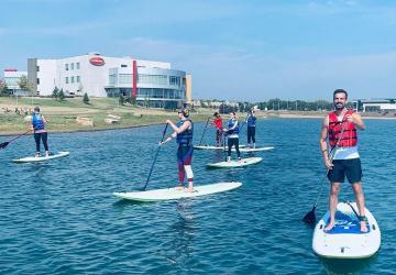
Lake Oahe is the largest of the Great Lakes reservoirs. It’s 231 miles long and 205 feet deep at the Oahe Dam. Dedicated by President John F. Kennedy in 1962, Oahe Dam is one of a chain of six main stem projects in the upper Missouri River Basin. Construction of Oahe Dam began in 1948 and was completed in 1962. The dam measures 9,300 feet in length with a maximum height of 245 feet. Each of the seven turbines generate 112,290 kilowatts of power. Lake Oahe is the 4th-largest man-made reservoir in the United States. Named for a Lakota council lodge, Lake Oahe extends from Fort Pierre, South Dakota to Bismarck, North Dakota. Whether you swim, sail, fish or water-ski, Lake Oahe has just the spot. Boat Ramps are plentiful on the lake and marinas offer supplies as well as lodging.
The meeting of Lewis and Clark’s Corp of Discovery and the Teton Lakota nation is considered to be one of the most pivotal moments in the history of the Lewis and Clark Expedition. Differences in trade objectives, diplomacy, and the lack of an interpreter lead to an armed confrontation, the closest Lewis and Clark came to a premature end to their expedition. This meeting happened at the mouth of the Bad River in what today is known as Fischers Lilly Park. In June of 2004, Lilly Park was renamed Fischers Lilly Park and was certified by the National Park Service as a Lewis and Clark National Historic Trail site. Fischers Lilly Park hosts 12 RV pads with electrical outlets, available on a first-come, first-serve basis with no stay limit. Water and electric is available at each pad. The park also has playground equipment and a picnic shelter with electrical outlets and bathrooms, as well as a dump site. A boat ramp can also be found on the park side of the Bad River and the boat ramp off Deadwood St. is accessible to the park by a walking bridge over the Bad River.

Fort Pierre Landscape
If you are looking for a route through central South Dakota close to the Missouri River, with historic points of interest, and provides beautiful scenery, try the Native American Scenic Byway from Chamberlain to Fort Pierre. This 100-mile stretch of highway will take you through two of South Dakota’s nine Indian reservations, across the Missouri River, and is the only designated Native American Scenic Byway in the US. Members of the Okiciapiye (o-kee-chee-AA-pee-y) “helping each other out” Group have agreed to work together to fulfill the mission of the Native American Scenic Byway. According to the Vision Statement, “the Native American Scenic Byway is the gateway to a revealing cultural experience. It is a journey through the heart of the Teton Lakota Nation. It will allow visitors appropriate access to the history, tradition, development, and future of the Lakota people. Begin at the Information Center/Rest Area at exit 263 on I-90 at Chamberlain. Take SD Highway 50 north approximately fifteen miles. Turn northwest on BIA Highway 4 to Fort Thompson where you will cross the Missouri River. Once you have crossed the bridge, you will be on the Lower Brule Reservation. Take BIA Highway 10 (also called Highway 1806) through the town of Lower Brule. You’ll stay on this road northwest for about the next 65 miles to the junction of Highway 1806 and US Highway 83.
The building which presently houses the Verendrye Museum on Deadwood Street was built in 1933 and was originally the Legion Community Hall. The Historical Society of Old Stanley County had a vision of establishing a museum, which was realized in 1968 with the opening of the Verendrye Museum. Presently, the museum is operated by a voluntary board of directors and is funded by the patrons of the city and county. The Verendrye Museum is open from 9:00am to 5:00pm during the tourist season of Memorial Day through Labor Day. During the off season, see some museum displays at the Fort Pierre Log Cabin Information center located at 4 E. Main Ave. Special arrangements can also be made to visit the museum in the off season. Call 605-223-7761 for more information.
Contact Information
- Fort Pierre Information Center, 04 E Main Ave, PO Box 461, Fort Pierre, SD 57532
- Phone: 605-223-7761
- Email: [email protected]
- Website: fortpierre.com
Source: City of Fort Pierre

